
This is an update of an article originally published in the Courier in April of 2016. Since then, another park was developed that also includes Shoupades: Discovery Park on the Chattahoochee River in Mableton.
The clear view of Atlanta’s skyline from the hill makes it obvious why it was valuable territory for desperate, retreating Confederate troops in the Summer of 1864. The hill is part of a high ridge overlooking the city and the Chattahoochee River valley. The river was the last major geographic barrier to the advancing federal troops, who were determined to capture Atlanta, an important transportation and supply center for the Confederacy. Both armies were facing each other from hastily dug defensive trenches.
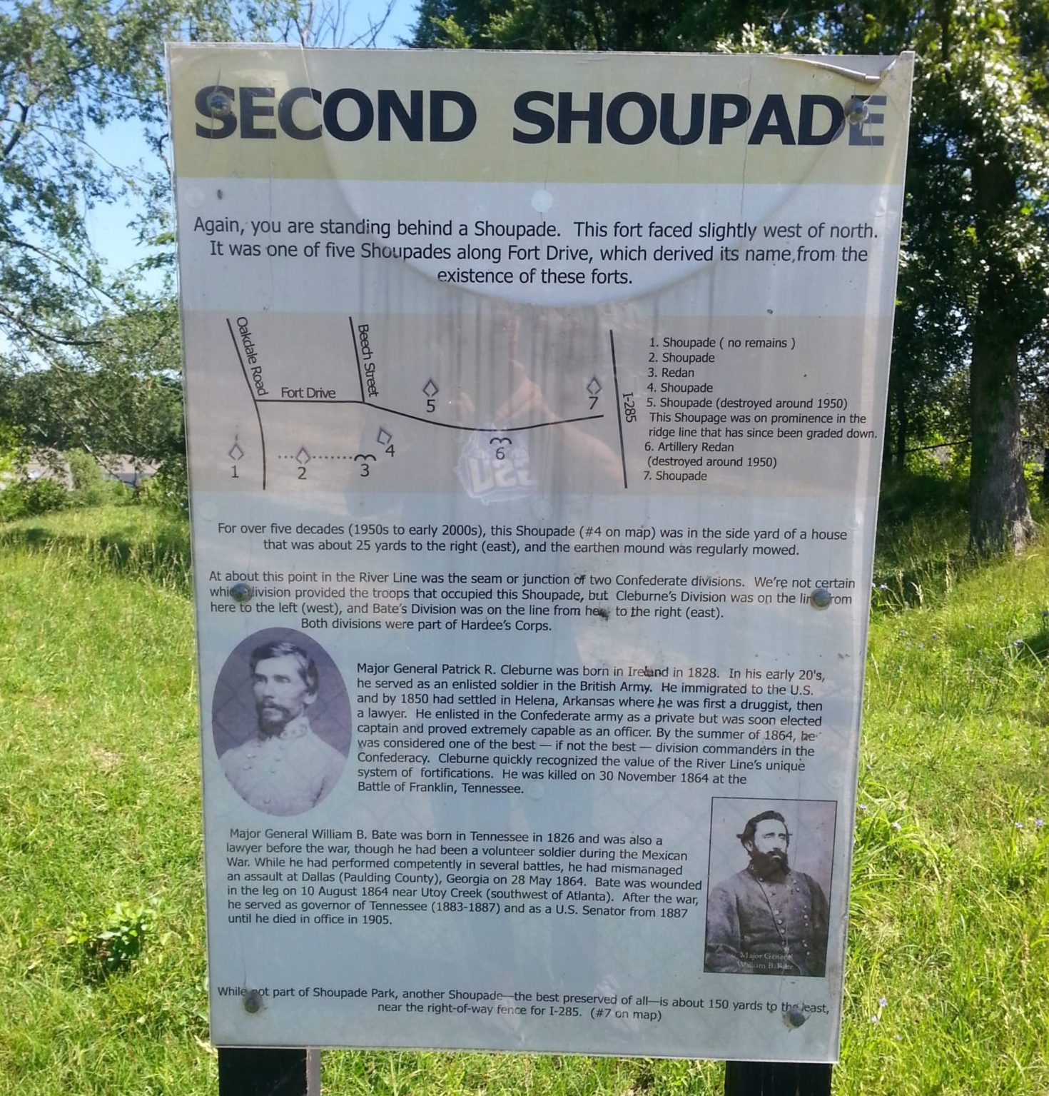
The ridge was an excellent place for a line of earthwork fortifications and artillery, intended to halt Sherman’s advance. It was high ground: easy to defend and hard to attack.
The hill is now the site of Shoupade Park in Cobb County, and it features the earthwork remains of two shoupades and an artillery redan. Shoupades were a unique series of fortifications built along the Chattahoochee River one month prior to the Battle of Atlanta. Construction was supervised by their designer, Confederate Brig. Gen. Francis Shoup. Shoup was under the command of General Joseph Johnston, so the entire row of fortifications became known as Johnston’s River Line.
Thirty-six shoupades were built. Nine remain today, in the form of earthwork mounds that served as the foundation for small triangular wooden forts. The complete structures, earthen and wooden, were 16 feet tall, with ledges for riflemen, and a ground level interior for the soldiers who reloaded the rifles. The individual forts were arranged in a sawtooth pattern to catch advancing enemy troops in crossfire. Each shoupade would hold about 80 soldiers.
Civil War historian Michael Shaffer, interviewed at Kennesaw State University, explained the decision to build them, and how construction began.
“Shoup had the idea for this very unique series of fortifications … He received approval from Johnston, in mid-June of 1864 … Shoup originally envisioned a line stretching for about four miles, which would have covered a point slightly above the Western & Atlantic railroad crossing of the Chattahoochee River. And that was really their major concern. They wanted to protect the rail line, because the Western & Atlantic and trains out of Atlanta supplied the Confederate army.”
Shaffer said the construction was done by about 1,000 enslaved persons, along with injured soldiers recruited from local military hospitals. At Johnston’s request the line was extended to six miles, to include a ferry crossing on the road that later became Bankhead Highway.
Sherman wrote after the war that the shoupades were “the best line of field intrenchments I have ever seen.” But the shoupades were never tested in combat. Faced with a difficult obstacle, Sherman did the sensible thing, and went around them, crossing the river to the north.
Over the decades after the Civil War most of the shoupades fell victim to the expansion of metro Atlanta, until by the late 1990s there were only nine of the original 36 left.
Roberta Cook is the president and founder of the River Line Historic Area, an organization involved in historic preservation and environmental issues along the Chattahoochee River in Cobb County, from Vinings southward to the area just north of Six Flags Over Georgia. In a phone interview she described the process of preserving the two shoupades and making them the centerpiece of the park.
“First of all it was the result of development … On one side of what’s now a park … there were massive apartments, I think they were called the Highland Apartments, something like that, and on the other side of the park, single family homes on large lots. A developer started land assemblage. It changed hands a couple of times. You know how developers flip properties. And it ended up in the hands of Pulte Homes, and they did the rezoning for both sides of what we call a park today.”
Cook said that during the public comment period, when Pulte brought the request to the county, a number of community organizations requested stipulations for rezoning the property. They asked Pulte to erect interpretive signs, a gate at the entrance, and fencing around the shoupades. They requested that Pulte then donate the land surrounding the shoupades to Cobb County. Pulte agreed to those terms, and the result was Shoupade Park.
The park is easy to miss, but it’s at 4770 Oakdale Road, on the east side of the road, between Dunagan Drive and Fort Drive in Smyrna. There is limited parking directly in front of the black metal gate. Shoupade Park is a unique preservation project, and well worth a visit for anyone interested in Atlanta or Civil War history.