[This is an installment in the series “Accidentally car-free” about getting around Cobb County without the use of a car. To see a list of the entire series visit this link. To see how this project began, read the first article in the series by following this link.]
By Larry Felton Johnson
This particular errand on foot was to the Lewis Ray branch of the Cobb County Public Library. I participate in a monthly virtual meeting called the Graphic Novel Book Club, hosted from the South Cobb Regional Library, but an online-only event.
Each month we read a graphic novel and discuss it on the fourth Monday of each month from 6 – 7 p.m. The nature of the novels vary considerably, from action/adventure and fantasy novels (the sort of things many people think of when they hear the phrase ‘graphic novel’), to novels that take up serious topics: (social justice, LGBTQ+ issues, coming-of-age stories).
Sometimes the novels are available in digital format, sometimes not.
The September selection, “Stitches,” by David Small, was not available from the Cobb Public Library in digital format, so I had to pick up a copy from a library branch. The closest branch to me is the Lewis Ray Library on Oakdale Road, so I had a hold put on it for that branch so a copy would be sent there for me to pick up.
After the library sent me a notice it had arrived, I scheduled my walk.
According to Google Maps, the route I took was 3.6 miles, or an hour and fifteen minutes each way. I actually made much better time than that (I’m a fast walker) even though I stopped to take photos.

The beginning of the walk took me over the same route up Oakdale Road to Highlands Parkway and a small section of South Cobb Drive that I’ve covered in previous articles, so I began photographing when I made the turn onto Oakdale from South Cobb Drive, northward toward the library branch.
It was a cloudy afternoon, so the tree-cover on the route plus the overcast made the photos turn out darker than usual, but I decided to leave the the way my eyes saw them, rather than lighten the images.
When I think of the north portion of Oakdale Road I usually think of the upscale subdivisions built within the past 10 or 20 years. But the first things you see along the road are things built much earlier, like this convenience store that has been converted to a store-front church. I have no idea if the church still occupies the building.

The photo below is pretty typical of the first quarter-mile or so of the route. If I had to guess, I’d say most of these houses were built between 1975 and 1995.

One thing that should be evident about nearly this entire section of Oakdale Road, from South Cobb Drive northward to the Lewis Ray Library, is that the conditions for pedestrians are good. All along the route I saw people walking, including people pushing strollers, walking dogs, and doing fast exercise walks. The sidewalks are good, and there are only a few gaps in sidewalks.
There were a couple of things of interest along the way.
The first one I encountered was a stand of bamboo on one of two adjacent undeveloped lots. The bamboo was tall and covered a large area.

Shortly north of there on the opposite side of the street was Shoupade Park, the site of Civil War earthworks that we’ve covered in the past.

I then passed the upcoming site of the Silver Comet Trail extension which will cross Oakdale Road, with Plant Atkinson Road to the east, and the rest of the Silver Comet Trail to the west.
Multi-use paths usually don’t provide a means of practical shopping trips for me, even when I’ve had a well-maintained bike, but this is an exception. When the extension of the Silver Comet is finished the Oakdale Road crossing of the trail will provide me with access to the Kroger to the east (at South Atlanta Road where the extension crosses North Church Lane), the Publix and Sprouts Farmers Market at the East West Connector, and if I feel like a good cycling workout, the Lidl, Kroger, Publix and a bunch of other destinations on Floyd Road.
So please, Cobb DOT and PATH! Finish that extension!
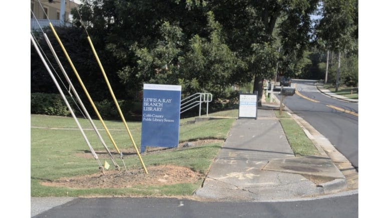
Finally I arrived at the Lewis Ray Library.


And here’s the book that I went to pick up.

What’s next in this series?
Every article so far has been about walking to destinations, and even for the closest destinations I’ve covered (Chattahoochee Coffee Company, the Publix on Veterans Memorial Highway) the time commitment is considerable.
So my next focus is going to be getting my bicycle roadworthy so I can increase my reach and decrease the time spent in travel.
I’ve gotten a chain-cleaning and oiling kit, since having a clean and well-oiled chain is necessary before I can even evaluate what my next steps are. I suspect I might need to change the chain. The tires might need replacing too. Derailleur adjustments will almost certainly be needed. That brakes and the various cables will need to be checked out.
I’ll write in this series about my relearning experience with day-to-day bike mechanics.