The National Weather Service issued a hazardous weather outlook for Cobb County and other parts of north and central Georgia on Friday, June 21, 2024.
Isolated thunderstorms are possible today to the south and east of Macon. Scattered storms are possible Saturday through next Thursday over the entire region, with the greatest chance being Tuesday through Thursday.
High heat is expected to move back into the region over the weekend, with possible heat index of 100 degrees and greater.
What is in the hazardous weather outlook?
Here is an excerpt from the hazardous weather outlook:
This Hazardous Weather Outlook is for portions of North and Central
Georgia.
.DAY ONE…Today and Tonight…
Isolated thunderstorms are possible over areas south and east of
Macon this afternoon and evening. Strong or severe storms are not
expected at this time.
.DAYS TWO THROUGH SEVEN…Saturday through Thursday…
Scattered thunderstorms will be possible over much of the area
through Thursday with the greatest chances on Tuesday, Wednesday
and Thursday. Some storm could be strong with heavy rain,
lightning and gusty winds.
Extreme heat will also be possible with heat index values around
or above 100 expected Saturday through Thursday.
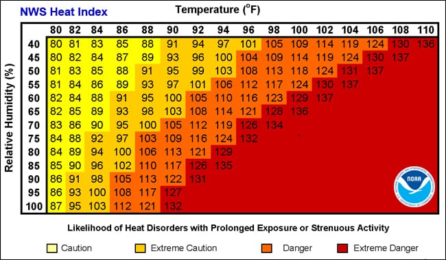
What is the heat index?
The NWS defines the heat index as follows on its website:
The heat index, also known as the apparent temperature, is what the temperature feels like to the human body when relative humidity is combined with the air temperature. This is an important consideration for the human body’s comfort. When the body gets too hot, it begins to perspire or sweat to cool itself off.
What counties are affected in the hazardous weather outlook?
The following counties are listed in the outlook:
Baldwin, Banks, Barrow, Bartow, Bibb, Bleckley, Butts, Carroll, Catoosa, Chattahoochee, Chattooga, Cherokee, Clarke, Clayton, Cobb, Coweta, Crawford, Crisp, Dade, Dawson, DeKalb, Dodge, Dooly, Douglas, Emanuel, Fannin, Fayette, Floyd, Forsyth, Gilmer, Glascock, Gordon, Greene, Gwinnett, Hall, Hancock, Haralson, Harris, Heard, Henry, Houston, Jackson, Jasper, Jefferson, Johnson, Jones, Lamar, Laurens, Lumpkin, Macon, Madison, Marion, Meriwether, Monroe, Montgomery, Morgan, Murray, Muscogee, Newton, North Fulton, Oconee, Oglethorpe, Paulding, Peach, Pickens, Pike, Polk, Pulaski, Putnam, Rockdale, Schley, South Fulton, Spalding, Stewart, Sumter, Talbot, Taliaferro, Taylor, Telfair, Toombs, Towns, Treutlen, Troup, Twiggs, Union, Upson, Walker, Walton, Warren, Washington, Webster, Wheeler, White, Whitfield, Wilcox, Wilkes, Wilkinson
About the National Weather Service
The National Weather Service (NWS) is a part of the National Oceanic and Atmospheric Administration (NOAA).
The NWS describes its role as follows:
The National Weather Service (NWS) provides weather, water, and climate forecasts and warnings for the United States, its territories, adjacent waters and ocean areas, for the protection of life and property and the enhancement of the national economy. These services include Forecasts and Observations, Warnings, Impact-based Decision Support Services, and Education in an effort to build a Weather-Ready Nation. The ultimate goal is to have a society that is prepared for and responds to weather, water and climate events.
Read all the Cobb County Courier climate and weather coverage by following this link.