The heat index might rise above 100 in portions of north and central Georgia Monday, according to the National Weather Service, and Cobb County is among one of the counties listed.
The NWS defines the heat index as follows on its website:
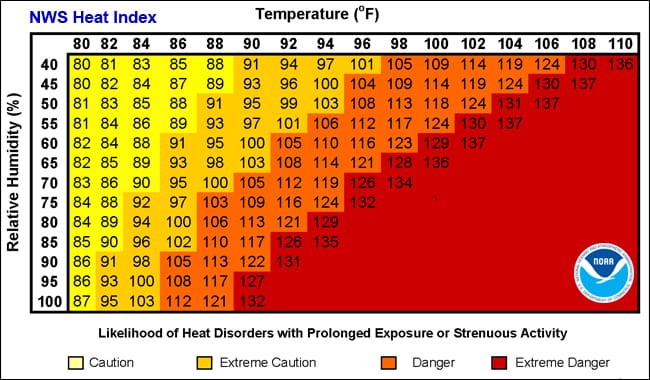
The heat index, also known as the apparent temperature, is what the temperature feels like to the human body when relative humidity is combined with the air temperature. This has important considerations for the human body’s comfort. When the body gets too hot, it begins to perspire or sweat to cool itself off.
The NWS issued a hazardous weather outlook for Cobb County and much of the rest of north Georgia that included the possibility of isolated thunderstorms today, Sunday June 12, and a heat index above 100 starting Monday.
What is in the hazardous weather outlook?
Here is an excerpt from the hazardous weather outlook:
This Hazardous Weather Outlook is for portions of North and
Central Georgia.
.DAY ONE…Today and Tonight…
Isolated to scattered thunderstorms are expected across portions
of central Georgia this afternoon and evening. A few storms may
become strong, capable of producing gusty winds, frequent
lightning, and locally heavy rainfall.
.DAYS TWO THROUGH SEVEN…Monday through Saturday…
There is potential for afternoon heat index values to be in excess
of 100 in portions of north and central Georgia from Monday
through Saturday.
Scattered thunderstorms are possible each day from Monday through
Thursday, primarily during the afternoon and evening. Isolated
thunderstorms will then be possible mainly in central Georgia on
Friday and Saturday.
What time period does it cover?
The possibility of isolated to scattered thunderstorms lasts from Sunday afternoon through Thursday, while the possible high heat index is forecast through Saturday.
What counties are affected in the hazardous weather outlook?
The following counties are listed in the outlook:
Baldwin, Banks, Barrow, Bartow, Bibb, Bleckley, Butts, Carroll, Catoosa, Chattahoochee, Chattooga, Cherokee, Clarke, Clayton, Cobb, Coweta, Crawford, Crisp, Dade, Dawson, DeKalb, Dodge, Dooly, Douglas, Emanuel, Fannin, Fayette, Floyd, Forsyth, Gilmer, Glascock, Gordon, Greene, Gwinnett, Hall, Hancock, Haralson, Harris, Heard, Henry, Houston, Jackson, Jasper, Jefferson, Johnson, Jones, Lamar, Laurens, Lumpkin, Macon, Madison, Marion, Meriwether, Monroe, Montgomery, Morgan, Murray, Muscogee, Newton, North Fulton, Oconee, Oglethorpe, Paulding, Peach, Pickens, Pike, Polk, Pulaski, Putnam, Rockdale, Schley, South Fulton, Spalding, Stewart, Sumter, Talbot, Taliaferro, Taylor, Telfair, Toombs, Towns, Treutlen, Troup, Twiggs, Union, Upson, Walker, Walton, Warren, Washington, Webster, Wheeler, White, Whitfield, Wilcox, Wilkes, Wilkinson
About the National Weather Service
The National Weather Service (NWS) is a part of the National Oceanic and Atmospheric Administration (NOAA).
The NWS describes its role as follows:
The National Weather Service (NWS) provides weather, water, and climate forecasts and warnings for the United States, its territories, adjacent waters and ocean areas, for the protection of life and property and the enhancement of the national economy. These services include Forecasts and Observations, Warnings, Impact-based Decision Support Services, and Education in an effort to build a Weather-Ready Nation. The ultimate goal is to have a society that is prepared for and responds to weather, water and climate events.
Read all the Cobb County Courier climate and weather coverage by following this link.