
Heat index values above 100 degrees are forecast across central and parts of north Georgia Tuesday afternoon, with potentially hazardous heat continuing through Saturday. Thunderstorm chances are also expected to increase beginning Thursday and continue through the end of the week.
The National Weather Service issued a hazardous weather outlook for north and central Georgia for Tuesday, September 1, 2026.
Weather reports can be packed with unfamiliar terms. Our plain-English guide to understanding weather reports explains what they mean—and what you should pay attention to.
What is in the Hazardous Weather Outlook?
The hazardous weather outlook states the following:
426 AM EDT Tue Sep 1 2026
This Hazardous Weather Outlook is for north and central Georgia.
.DAY ONE…Today and Tonight…
Heat index values are forecast to exceed 100 degrees across
central and portions of north Georgia this afternoon..DAYS TWO THROUGH SEVEN…Wednesday through Monday…
Afternoon thunderstorm chances will gradually increase starting
Thursday and through the end of the week.Heat index values will exceed 100 degrees and may approach
hazardous levels for parts of the area Wednesday through
Saturday.
Counties included in the alert
- Baldwin
- Banks
- Barrow
- Bartow
- Bibb
- Bleckley
- Butts
- Carroll
- Catoosa
- Chattahoochee
- Chattooga
- Cherokee
- Clarke
- Clayton
- Cobb
- Coweta
- Crawford
- Crisp
- Dade
- Dawson
- DeKalb
- Dodge
- Dooly
- Douglas
- Emanuel
- Fannin
- Fayette
- Floyd
- Forsyth
- Gilmer
- Glascock
- Gordon
- Greene
- Gwinnett
- Hall
- Hancock
- Haralson
- Harris
- Heard
- Henry
- Houston
- Jackson
- Jasper
- Jefferson
- Johnson
- Jones
- Lamar
- Laurens
- Lumpkin
- Macon
- Madison
- Marion
- Meriwether
- Monroe
- Montgomery
- Morgan
- Murray
- Muscogee
- Newton
- North Fulton
- Oconee
- Oglethorpe
- Paulding
- Peach
- Pickens
- Pike
- Polk
- Pulaski
- Putnam
- Rockdale
- Schley
- South Fulton
- Spalding
- Stewart
- Sumter
- Talbot
- Taliaferro
- Taylor
- Telfair
- Toombs
- Towns
- Treutlen
- Troup
- Twiggs
- Union
- Upson
- Walker
- Walton
- Warren
- Washington
- Webster
- Wheeler
- White
- Whitfield
- Wilcox
- Wilkes
- Wilkinson
What is the heat index?
The NWS defines the heat index as follows on its website:
The heat index, also known as the apparent temperature, is what the temperature feels like to the human body when relative humidity is combined with the air temperature. This has important considerations for the human body’s comfort. When the body gets too hot, it begins to perspire or sweat to cool itself off.
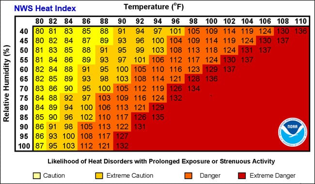
Chart from NOAA showing relationship between relative humidity and temperature in heat index
About the National Weather Service
The National Weather Service (NWS) is a federal agency within the National Oceanic and Atmospheric Administration (NOAA), part of the U.S. Department of Commerce. Its primary mission is to provide weather, water, and climate data, forecasts, and warnings to protect life and property and to enhance the national economy.
Headquartered in Silver Spring, Maryland, the NWS operates through a network of six regional headquarters and more than 100 local Weather Forecast Offices (WFOs) across the country. These offices issue weather forecasts, warnings, advisories, and watches tailored to specific geographic areas.
Metro Atlanta is served by the National Weather Service’s Atlanta/Peachtree City Weather Forecast Office, located in Peachtree City. The office issues forecasts, watches, warnings and other weather information for much of north and central Georgia, including Cobb County.
The NWS also runs specialized centers, including the Storm Prediction Center (SPC) for severe weather outlooks, the National Hurricane Center (NHC) for tropical storm tracking, the Weather Prediction Center (WPC) for national forecast guidance, and the Space Weather Prediction Center (SWPC) for solar activity that may affect Earth-based systems.
NWS forecasts and alerts are based on data from a combination of satellites, radar systems, weather balloons, surface observation stations, and computer models. The agency collaborates with emergency managers, broadcasters, government agencies, and the public to ensure that timely and accurate information is disseminated during weather events.
Its services are made available to the public at no cost, and its warnings—such as tornado warnings, flash flood alerts, and winter storm advisories—serve as official guidance for public safety and emergency response.
Editor’s note: AI was used in the production of this article. To read about when and why we made use of AI, read our article “How, When and Why the Cobb County Courier uses AI.”