According to this morning’s report from the National Weather Service, the hazardous weather outlook continues for Cobb County, with thunderstorms, flooding, and high wind gusts possible beginning this evening and continuing through the weekend. The flooding is forecast to affect Powder Springs and Austell near Sweetwater Creek, and is expected to be minor, according to the NWS.
The flood statement reads as follows:
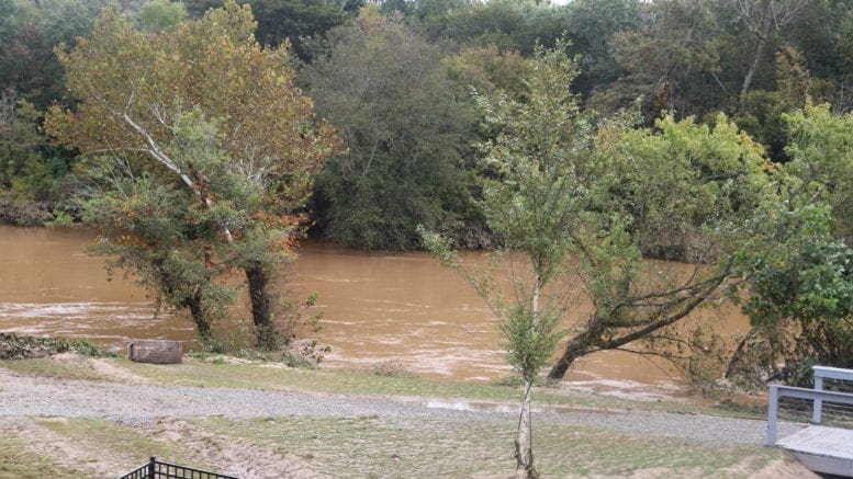
Flood Statement
National Weather Service Peachtree City GA 305 AM EST
Sat Jan 1 2022 …The Flood Warning continues for the following rivers in Georgia… Sweetwater Creek near Austell affecting Douglas and Cobb Counties. For the Sweetwater Creek…including Powder Springs, Powder Springs, Northwest Austell, Powder Springs, Austell, Austell, Austell 6S… Minor flooding is forecast.
The hazardous weather outlook reads as follows:
.DAY ONE…Today and Tonight… There is a slight chance for thunderstorms today for north Georgia, with likely thunderstorms moving across the area late this evening through the morning hours. Some of the storms could become strong to severe. The primary threats will be damaging wind gusts, periods of heavy rain, and an isolated brief tornado
. .DAYS TWO THROUGH SEVEN…Sunday through Friday… Additional rounds of thunderstorms will continue across portions of north and central Georgia on Sunday. Some of these storms may be severe with damaging wind gusts, periods of heavy rainfall, and an isolated brief tornado. There is also a possibility for some mixed wintry precipitation in far northern Georgia late Sunday night into early Monday morning. Stay tuned to the latest forecasts throughout the weekend for more details
. .SPOTTER INFORMATION STATEMENT… Spotter activation is not requested but spotters are encouraged to submit reports of severe weather through the web by going to weather.gov/atlanta. Please relay any information about observed severe weather to the NWS while following all local, state, and CDC guidelines.
7-day forecast
The following is the NWS 7-day weather forecast, centered on Dobbins ARB in Marietta:
New Year’s Day A 30 percent chance of showers, mainly after 2 p.m. Mostly cloudy, with a high near 73. Southwest wind 10 to 15 mph, with gusts as high as 25 mph.
Tonight A chance of showers and thunderstorms, then showers and possibly a thunderstorm after 1 a.m.. Low around 60. South wind around 15 mph, with gusts as high as 25 mph. Chance of precipitation is 80%. New rainfall amounts between a quarter and half of an inch possible.
Sunday Showers and possibly a thunderstorm before 1 p.m., then a chance of showers between 1 p.m and 2 p.m., then showers likely and possibly a thunderstorm after 2 p.m. Temperature falling to around 56 by 5 pm. West wind around 10 mph, with gusts as high as 15 mph. Chance of precipitation is 90%. New rainfall amounts between a quarter and half of an inch possible.
Sunday Night Showers likely and possibly a thunderstorm before 1 a.m., then a chance of showers. Mostly cloudy, with a low around 32. Northwest wind 10 to 15 mph, with gusts as high as 30 mph. Chance of precipitation is 70%.
Monday Sunny, with a high near 45. Northwest wind 10 to 15 mph, with gusts as high as 25 mph.
Monday Night Clear, with a low around 31.
Tuesday Sunny, with a high near 49.
Tuesday Night Partly cloudy, with a low around 38.
Wednesday Mostly cloudy, with a high near 55.
Wednesday Night A 20 percent chance of showers. Mostly cloudy, with a low around 43.
Thursday Showers likely and possibly a thunderstorm. Mostly cloudy, with a high near 57. Chance of precipitation is 60%.
Thursday Night A 30 percent chance of showers. Mostly cloudy, with a low around 23.
FridayMostly sunny, with a high near 38.
About the National Weather Service
The National Weather Service (NWS) is a part of the National Oceanic and Atmospheric Administration (NOAA).
The NWS describes its role as follows:
The National Weather Service (NWS) provides weather, water, and climate forecasts and warnings for the United States, its territories, adjacent waters and ocean areas, for the protection of life and property and the enhancement of the national economy. These services include Forecasts and Observations, Warnings, Impact-based Decision Support Services, and Education in an effort to build a Weather-Ready Nation. The ultimate goal is to have a society that is prepared for and responds to weather, water and climate events.
Read all the Cobb County Courier climate and weather coverage by following this link.