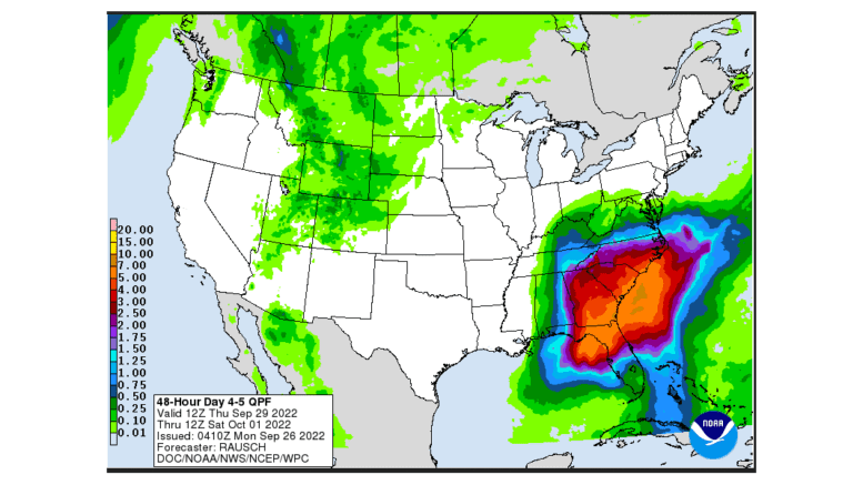
The path of now-tropical storm Ian has shifted eastward, although all 159 counties in Georgia are still under State of Emergency, with strong winds possible even in parts of Georgia not directly in the path of the storm.
Flooding is possible in the coastal counties of Georgia, and northward into South Carolina.
North and central Georgia, meanwhile, continue to be under a wind advisory.
The office of Governor Brian Kemp issued an update, which we’ve reprinted below:
Atlanta, GA – Governor Brian P. Kemp today joined state and local emergency management officials, local leaders, and others in Savannah to provide an update on Tropical Storm Ian preparations and the state’s planned response. The State of Emergency issued by Governor Kemp on Tuesday went into effect this morning at 7 a.m. for all 159 of Georgia’s counties, making state resources available to local governments and entities within the hurricane impact area. The Georgia Emergency Management and Homeland Security Agency (GEMA/HS) State Operations Center is now at a Level 1 full-scale activation and continues to monitor Tropical Storm Ian’s progress. Teams from the relevant state agencies are also standing by to deploy to affected counties, when appropriate. The governor and emergency management officials are also coordinating with Georgia’s utility providers, who have been staging equipment, inspecting the right-of-way paths of power lines, and preparing to respond to any power outages homes and businesses may experience.
At this time, the Savannah Airport remains open and operational. The Savannah port terminal cleared any waiting vessels last night and operations will continue until 6 p.m. this evening. All vessels have also departed the Brunswick port terminal and pilot operations have ceased until the storm passes. The Georgia Ports Authority will reassess needs and an expected timeline for return to operations on Friday. The Georgia Department of Transportation closed the Sidney Lanier Bridge in Brunswick at 9 a.m. today, and Houlihan Bridge is closed to boat traffic only. Please visit www.dot.ga.gov for more information.
A number of Floridians have come to Georgia over the past several days, and Georgia is welcoming them with open arms. There is still reliable hotel/motel availability with sufficient capacity to meet demand. The tourism division of the Georgia Department of Economic Development has activated the Explore Georgia hurricane information webpage to help travelers and evacuees impacted by Tropical Storm Ian find hotel room openings and lodging availability, hours of operation for the state’s nine Visitor Information Centers, and links to emergency resources.
Current Weather Overview:
Ian weakened overnight and is now a tropical storm with maximum sustained winds of 65 mph. It is currently moving off the east-central coast of Florida to the northeast at 8 mph.
The forecast track has shifted to the east since yesterday, and Ian is expected to make a second landfall as a tropical storm in South Carolina tomorrow. This has also shifted potential impacts to Georgia eastward. Heavy rainfall (2 to 4 inches of accumulation) and gusty winds (30-40 mph) will still be possible in East and Southeast Georgia today and tomorrow. 3 to 5 feet of storm surge is still possible along the Georgia coast today and tomorrow morning. The storm will weaken inland overnight Friday before dissipating throughout the day on Saturday.
Significant impacts are still possible in eastern portions of Georgia even with the eastward track shift. A Tropical Storm Warning, Hurricane Watch, Storm Surge Warning, and Flood Watch remain in effect for the entire Georgia coast through tomorrow. A Wind Advisory is also in effect for much of North and Central Georgia. Please continue to monitor forecast updates from the National Hurricane Center, your local National Weather Service office, and reliable media outlets.
Resources for Those Affected
Governor Kemp urges all Georgians to remain weather alert and to take the necessary precautions to protect themselves and their families. Those directly impacted by the storm’s path are encouraged to consult GEMA/HS’ informational website.
Explore Georgia and state tourism partners are tracking the storm and updating the hurricane information webpage regularly with information on lodging and other resources.
The Department of Agriculture has also activated a disaster animal shelter that has capacity for 50 animals:
Macon, Bibb County
4214 Fulton Mill Road,
Macon, GA 31216
h the eastward track shift. A Tropical Storm Warning, Hurricane Watch, Storm Surge Warning, and Flood Watch remain in effect for the entire Georgia coast through tomorrow. A Wind Advisory is also in effect for much of North and Central Georgia. Please continue to monitor forecast updates from the National Hurricane Center, your local National Weather Service office, and reliable media outlets.
Resources for Those Affected
Governor Kemp urges all Georgians to remain weather alert and to take the necessary precautions to protect themselves and their families. Those directly impacted by the storm’s path are encouraged to consult GEMA/HS’ informational website.
Explore Georgia and state tourism partners are tracking the storm and updating the hurricane information webpage regularly with information on lodging and other resources.
The Department of Agriculture has also activated a disaster animal shelter that has capacity for 50 animals:
Macon, Bibb County
4214 Fulton Mill Road,
Macon, GA 31216
Further information on the Department of Agriculture’s response to Ian is available here.
Georgians are also encouraged to:
▪ Take appropriate action based on their location.
▪ Residents who are in vulnerable housing situations, including those in low-lying areas or at-risk floodplains, should consider relocating temporarily to higher ground.
▪ All of South and Coastal Georgia should pay close attention to guidance from local officials and review family emergency plans with those in their care.
| ▪ | Take appropriate action based on their location. |
| ▪ | Residents who are in vulnerable housing situations, including those in low-lying areas or at-risk floodplains, should consider relocating temporarily to higher ground. |
| ▪ | All of South and Coastal Georgia should pay close attention to guidance from local officials and review family emergency plans with those in their care. |
