
The National Weather Service issued a heat advisory for central Georgia that included a few metro counties on the list, including Cobb County.
Heat index values of greater than 105 are expected. Also, scattered thunderstorms are expected to continue throughout the region.
The heat advisory is effective from 11 a.m. until 8 p.m. Monday, July 8.
What is in the heat advisory?
Here is an excerpt from the hazardous weather outlook:
This Hazardous Weather Outlook is for portions of North and Central Georgia.
.DAY ONE…Today and Tonight…
A Heat Advisory is in effect from 11 AM until 8 PM today for all
of central and portions of east central Georgia. Heat index values
over 105 degrees are expected in these areas.
Scattered thunderstorms are expected this afternoon and evening.
Locally heavy rainfall and frequent lightning are the primary
concerns in the strongest storms.
.DAYS TWO THROUGH SEVEN…Tuesday through Sunday…
Isolated to scattered thunderstorms are possible in portions of
the area each day. Coverage of storms will generally be maximized
during the afternoon and evening hours each day. The risk for
severe weather remains low.
Heat index values over 100 to 105 degrees are also possible in
portions of the area on Tuesday and Wednesday.
What counties are affected?
The following counties are listed in the outlook:
Baldwin, Banks, Barrow, Bartow, Bibb, Bleckley, Butts, Carroll, Catoosa, Chattahoochee, Chattooga, Cherokee, Clarke, Clayton, Cobb, Coweta, Crawford, Crisp, Dade, Dawson, DeKalb, Dodge, Dooly, Douglas, Emanuel, Fannin, Fayette, Floyd, Forsyth, Gilmer, Glascock, Gordon, Greene, Gwinnett, Hall, Hancock, Haralson, Harris, Heard, Henry, Houston, Jackson, Jasper, Jefferson, Johnson, Jones, Lamar, Laurens, Lumpkin, Macon, Madison, Marion, Meriwether, Monroe, Montgomery, Morgan, Murray, Muscogee, Newton, North Fulton, Oconee, Oglethorpe, Paulding, Peach, Pickens, Pike, Polk, Pulaski, Putnam, Rockdale, Schley, South Fulton, Spalding, Stewart, Sumter, Talbot, Taliaferro, Taylor, Telfair, Toombs, Towns, Treutlen, Troup, Twiggs, Union, Upson, Walker, Walton, Warren, Washington, Webster, Wheeler, White, Whitfield, Wilcox, Wilkes, Wilkinson
What is the heat index?
The NWS defines the heat index as follows on its website:
The heat index, also known as the apparent temperature, is what the temperature feels like to the human body when relative humidity is combined with the air temperature. This has important considerations for the human body’s comfort. When the body gets too hot, it begins to perspire or sweat to cool itself off.
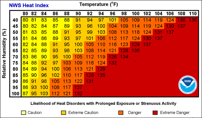
Chart from NOAA showing relationship between relative humidity and temperature in heat index
About the National Weather Service
The National Weather Service (NWS) is a part of the National Oceanic and Atmospheric Administration (NOAA).
The NWS describes its role as follows:
The National Weather Service (NWS) provides weather, water, and climate forecasts and warnings for the United States, its territories, adjacent waters and ocean areas, for the protection of life and property and the enhancement of the national economy. These services include Forecasts and Observations, Warnings, Impact-based Decision Support Services, and Education in an effort to build a Weather-Ready Nation. The ultimate goal is to have a society that is prepared for and responds to weather, water and climate events.
Read all the Cobb County Courier climate and weather coverage by following this link.