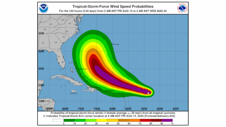
The National Hurricane Center (NHC) reports that Tropical Storm Erin is becoming better organized and is expected to become Hurricane Erin today, described by the NHC as “large and powerful.”
The NHC site published the following at 5 a.m. EDT Friday:
Erin is moving west-northwestward at an estimated motion of 285/15 kt. A subtropical ridge to the north will continue to steer the system west-northwestward into the weekend. A weakness in the ridge is forecast to develop early next week, and this will result in the system gradually turning northwestward, then northward by the end of the forecast period.
The guidance is in fairly good agreement through about 60–72 hours. After 72 hours, there are some differences in the forward speed and cross-track spread with the turn toward the north. The regional hurricane models lie along the western edge of the guidance envelope, with the GFS and Google DeepMind models remaining on the eastern edge. The latest NHC forecast is similar to the previous one in the short term, and was nudged slightly west beyond day 3, closer to some of the simple consensus aids. There is still uncertainty about what impacts Erin may bring to portions of the Bahamas, the east coast of the United States, and Bermuda in the long range.
The storm is in a favorable environment for strengthening, and it will likely intensify once the inner core becomes more organized. Sea surface temperatures have warmed to about 28°C and should continue to warm to near 30°C along the forecast track, with a slight decrease in shear expected over the next day or so.
Although SHIPS guidance depicts a slight increase in shear later this weekend, the upper-level wind pattern becomes a little more favorable with increasing mid-level RH values. The NHC forecast is similar to the previous with a steady rate of strengthening and lies near the consensus aids, with Erin forecast to become a hurricane later today, and a major hurricane late this weekend. Some of the hurricane regional models and the Florida State Superensemble depict a higher peak intensity than the current NHC forecast.
Regardless of the details, Erin will be a large and powerful hurricane over the southwestern Atlantic Ocean this weekend.
Above-normal Atlantic hurricane season expected
The National Weather Service posts that we are on track for an above-normal hurricane season this year.
The National Hurricane Center posted the following:
Forecasters from NOAA’s National Weather Service updated the number of expected named storms to 13-18 (with winds of 39 mph or greater), of which 5-9 could become hurricanes (winds of 74 mph or greater), including 2-5 major hurricanes (winds of 111 mph or greater).
The adjusted ranges are for the entire season from June 1 though November 30, and are inclusive of the four named tropical storms that have already formed. In the Atlantic basin, a typical hurricane season will yield 14 named storms, of which seven become hurricanes and three become major hurricanes.
The likelihood of above-normal activity is 50%, a 35% chance of a near-normal season, and a 15% chance of a below-normal season. This updated prediction is similar to the initial outlook issued in May.