The National Weather Service issued a hazardous weather outlook for Sunday, June 23, for Cobb County and other parts of north and central Georgia.
A very high heat index is expected across the affected region. Isolated to scattered thunderstorms are also expected in the east-central part of the region.
In this article, you will learn:
- What is in today’s National Weather Service alert
- What counties are included in the alert
- What is the heat index?
- What is meant by the terms “isolated” and “scattered”
- About the National Weather Service and what it does
What is in the statement?
The statement gives the following details:
This Hazardous Weather Outlook is for portions of North and
Central Georgia.
.DAY ONE…Today and Tonight…
Isolated to scattered thunderstorms are expected across portions
of east-central Georgia this afternoon. Thunderstorms that develop
will be capable of producing frequent lightning and locally heavy
rain.
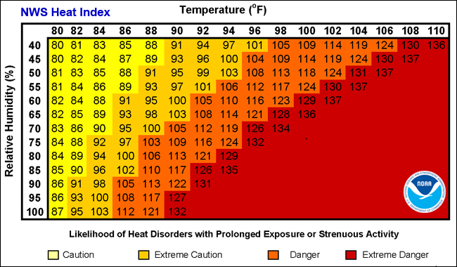
Very high heat index values around or above 100 are expected this
afternoon.
.DAYS TWO THROUGH SEVEN…Monday through Saturday…
Scattered thunderstorms will be possible over much of the area
each day through Saturday, with the greatest chances on Wednesday
and Thursday. Some storms could become strong and capable of
producing heavy rain, lightning and gusty winds.
Extreme heat will also be possible with heat index values around
or above 100 expected Monday through Saturday.
What counties are affected?
The following counties are included in the hazardous weather outlook:
Baldwin, Banks, Barrow, Bartow, Bibb, Bleckley, Butts, Carroll, Catoosa, Chattahoochee, Chattooga, Cherokee, Clarke, Clayton, Cobb, Coweta, Crawford, Crisp, Dade, Dawson, DeKalb, Dodge, Dooly, Douglas, Emanuel, Fannin, Fayette, Floyd, Forsyth, Gilmer, Glascock, Gordon, Greene, Gwinnett, Hall, Hancock, Haralson, Harris, Heard, Henry, Houston, Jackson, Jasper, Jefferson, Johnson, Jones, Lamar, Laurens, Lumpkin, Macon, Madison, Marion, Meriwether, Monroe, Montgomery, Morgan, Murray, Muscogee, Newton, North Fulton, Oconee, Oglethorpe, Paulding, Peach, Pickens, Pike, Polk, Pulaski, Putnam, Rockdale, Schley, South Fulton, Spalding, Stewart, Sumter, Talbot, Taliaferro, Taylor, Telfair, Toombs, Towns, Treutlen, Troup, Twiggs, Union, Upson, Walker, Walton, Warren, Washington, Webster, Wheeler, White, Whitfield, Wilcox, Wilkes, Wilkinson
What is meant by “isolated” and “scattered”?
The NWS defines “isolated” as follows:
A National Weather Service convective precipitation descriptor for a 10 percent chance of measurable precipitation (0.01 inch). Isolated is used interchangeably with few.
“Scattered” has the following definition:
When used to describe precipitation (for example: “scattered showers”) – Area coverage of convective weather affecting 30 percent to 50 percent of a forecast zone (s).
Isolated thunderstorms and scattered thunderstorms are two terms used to describe different distributions of thunderstorm activity within a particular area. The main difference lies in the extent of coverage and how the thunderstorms are spatially distributed:
- Isolated Thunderstorms:
- Isolated thunderstorms are relatively rare occurrences that happen sporadically and are generally confined to a limited area.
- These thunderstorms are often characterized by being few and far between, with significant gaps between individual storm cells.
- Typically, isolated thunderstorms cover less than 20% of the forecast area.
- Despite their isolated nature, these storms can still be intense and may produce heavy rain, lightning, gusty winds, and possibly hail.
- Scattered Thunderstorms:
- Scattered thunderstorms are more widespread than isolated thunderstorms and cover a larger portion of the forecast area.
- In a scattered thunderstorm scenario, numerous individual thunderstorms develop, but they are not continuous or widespread enough to be classified as a “line” or “cluster” of storms.
- Scattered thunderstorms generally cover between 30% to 50% of the forecast area.
- Although scattered thunderstorms are more widespread, they still leave considerable gaps between storm cells, and not everyone within the forecast area will necessarily experience a thunderstorm.
In summary, isolated thunderstorms are fewer in number and more localized, covering a smaller area with significant gaps between storms, while scattered thunderstorms are more widespread, covering a larger area with numerous individual storms occurring somewhat randomly across the forecast area.
What is the heat index?
The NWS defines the heat index as follows on its website:
The heat index, also known as the apparent temperature, is what the temperature feels like to the human body when relative humidity is combined with the air temperature. This has important considerations for the human body’s comfort. When the body gets too hot, it begins to perspire or sweat to cool itself off.
About the National Weather Service
The National Weather Service (NWS) is a part of the National Oceanic and Atmospheric Administration (NOAA).
The NWS describes its role as follows:
“The National Weather Service (NWS) provides weather, water, and climate forecasts and warnings for the United States, its territories, adjacent waters and ocean areas, for the protection of life and property and the enhancement of the national economy.
“These services include Forecasts and Observations, Warnings, Impact-based Decision Support Services, and Education in an effort to build a Weather-Ready Nation. The ultimate goal is to have a society that is prepared for and responds to weather, water and climate events.”
>>> Read all the Cobb County Courier climate and weather coverage by following this link.