In a press release describing the road-brining work the Georgia Department of Transportation is doing in preparation for the winter storm expected to hit Cobb County and much of the rest of north Georgia tonight, the GDOT commissioner had a message for Georgians in the path of the storm.
“We are monitoring the storm closely and adjusting response plans as needed. As the forecast has evolved, it has become more likely that a significant area of Georgia will experience icy conditions as part of the incoming storm system. Ice adds a level of complexity, as well as increased danger, for our crews and motorists,” said Georgia DOT Commissioner Russell McMurry. “We anticipate downed trees, limbs and powerlines. It is critical that motorists take this storm system very seriously and stay off the roads through the end of the event to give our crews the space needed to work.”
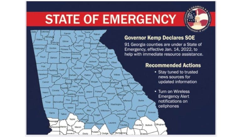
Governor Brian Kemp has issued a State of Emergency.
In addition, the GDOT released a video in which GDOT Media Strategist Natalie Dale describes the “Three things you should know …” as the winter storm approaches.
The three things boil down to:
- There is a winter storm rapidly approaching, expected to hit hardest north of I-20
- You should stay off the roads until the storm is completely over
- The GDOT is working to prepare the roads, with brine trucks deployed
Latest Hazardous Weather Outlook from the National Weather Service
In addition to two earlier advisories, the National weather service added the following one this morning:
.DAY ONE...Today and Tonight...

Portions of north Georgia will see rain mixing with or changing to
snow, sleet, and freezing rain mainly tonight through Sunday. A
Winter Storm Warning is in effect for far northeast Georgia and a
Winter Weather Advisory is in effect for generally along and
north of the I-20 corridor. Please see the associated WSWFFC
product for more details.

Strong winds of 25 mph gusting up to 35 mph are likely tonight
into Sunday for north GA and much of central Georgia along with
gusts up to 50 mph in the northern higher elevations. A Wind
Advisory has been issued accordingly for north Georgia and much
of central GA.


.DAYS TWO THROUGH SEVEN...Sunday through Friday...

Rain mixing with or changing to snow, sleet, and freezing rain
will continue through Sunday across portions of north Georgia. The
Winter Storm Warning and Winter Weather Advisory will continue to
be in effect until midnight Sunday night. Gusty winds will
continue through Sunday morning and the Wind Advisory will be in
effect until 12 PM. Lingering black ice potential will continue
through Monday morning and a Special Weather Statement will likely
be issued in the future.

There is a slight chance of some light snow in the far north for
late Thursday into Friday, though there is great uncertainty this
far out in the forecast. Otherwise no other hazardous weather is
expected.