The National Weather Service, in addition to its seven-day forecasts and various levels of alerts, also publishes a more conversational statement on weather prospects for each area called the “Area Forecast Discussion,” that goes into a bit more detail than the forecasts and outlooks do. It also considers the uncertainties in the forecast.
Today’s discussion stated that the metro Atlanta area has a reprieve from the active storm, but that black ice continues to be a possible hazard in the area.
The discussion also states that while the area might be slightly below the criteria for a wind advisory, it’s close enough that the NWS decided not to cancel the one they put in place to expire at 7 p.m. this evening.
The discussion also said that the weather service models show a cold front moving into the area on Thursday, January 20, and Friday, January 21.
National Weather Service Peachtree City GA 414 AM EST Mon Jan 17 2022 …Winter Precip Possible Again Late Week…
.SHORT TERM /Today through Tuesday/…
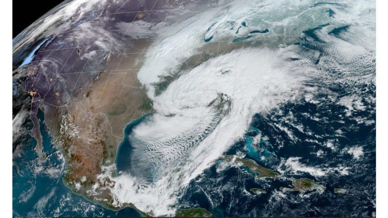
Finally a bit of a reprieve from the active pattern in the wake of the winter storm and the main lingering impacts will be possible black ice this morning across mainly the northern majority of the CWA from any freezing of moisture left on roadways and some enhanced west to NW gradient winds. Will continue to cover the black ice potential with the Special Weather Statement through mid-morning as we start to warm up aside from the northern mtns which may actually stay below freezing through the day. Have decided to continue the Wind Advisory today area-wide as we may be slightly below criteria in parts of the area but close enough to warrant not canceling. Otherwise a weak upper wave and some attendant moisture flirts with the far northern CWA this morning so have a slight chance of some light snow in parts of the far north but no accumulations. A deck of cold advection stratocu looks to persist into the afternoon for a large part of the area aside from perhaps some earlier scattering in our typical northeast downslope zone.
Tuesday looks to be quiet as we are dry and mostly clear as ridging prevails. The NW flow aloft transitions more to zonal later in the afternoon and we actually get a south component back to the sfc wind. The resultant afternoon highs moderate warmer though stay several degrees below climo as most locations look to make it to the upper 40s to 50s. Baker
.LONG TERM /Tuesday Night through Sunday/
… Progressive weather pattern continues into the extended period with the first of many features approaching the state midweek. Extended models are in agreement with cold front moving into the Thursday with moisture axis remaining positioned over the state through early Friday.
At onset of this event, there is a possibility of a light wintry mix over north Georgia early Thursday where the moisture and colder temperatures combine, but the big forecast concern continues to be the winter precip potential for mainly Friday. The extended models only seem to agree on the potential for winter precip, but solutions continue to diverge with respect to Friday timing and precip type. Each seems to struggle with how to resolve surface low`s warm, moist advection and wedge feature.
The 00Z GFS, which at this time seems to have the best run- to- run consistency with producing winter precip, shows a combination SN/FZRA event playing out over the eastern half of the state, centered generally along I-20. The 00Z Euro, after showing a non- event in the 12Z run, is back to showing a more robust FZRA event unfolding in the Carolinas and down into eastern Georgia and higher snow totals over north Georgia (including all of the ATL metro).
Given the high forecast uncertainty, have continued to mention RA/SN mixed precip in the grids for late Thursday through early Saturday with periods of all SN over generally north Georgia. Euro is slower than GFS to exit moisture on Saturday, but consistent with other extended models with showing chilly sub- seasonal temperatures in the 20s Sunday morning to keep whatever winter impacts lingering through the weekend. This has the potential to be a big event, but without a convergence in model solutions and better run-to-run consistency, messaging timing, amounts, and impacts will be challenging. The forecast will certainly change over the coming days, so stay tuned.