As the Courier shifts its focus to provide heavier coverage of quality-of-life issues in the Cobb County, including transportation and the environment, we’re expanding and repurposing some of the census-related articles we’ve published over the past few years.
This article takes a look at the distribution of jobs within the county. Without knowing where the jobs are, it’s impossible to know what sort of transportation and public transit systems to develop. It would also be difficult to develop land use and zoning policies without knowledge of the existing commercial and industrial layout in the county.
This is another reworking and expansion of an earlier article we ran examining Cobb County by the Numbers, using data and tools from the U.S. Census Bureau.
After the Census Bureau began publishing results from the decennial census, and introduced a new set of easy-to-use tools for getting at the numbers, the Courier published a series of articles making use of the new tools.
Unfortunately those articles were introduced when the COVID pandemic dominated the news, so the census articles languished with low traffic, even though the information was important to an informed citizenry.
This article uses the OnTheMap tool from the U.S. Census Bureau to determine where jobs within Cobb County are concentrated.
The U.S. Census Bureau gathers those figures in their American Community Survey and provides tools that allow people to map, visualize and create tables and charts from that data.
And they are surprisingly easy to use. Just follow this link to the OnTheMap tool, or scroll to the videos at the bottom of the article that instruct you on how to learn things about employment in any area of the U.S.
I’m going to repeat a couple of caveats I gave in the article about what the commute flows look like in Cobb County. One is that gathering the data is time-consuming for the Census Bureau, so there is a time lag before sets of data become available. This article was written based on the 2019 American Community Survey.
The second is that the COVID pandemic affected both the gathering of the data, and the job market itself, although some economists don’t believe the market has been affected as severely as earlier news reports would indicate.
With those out of the way, let’s get right to the point.
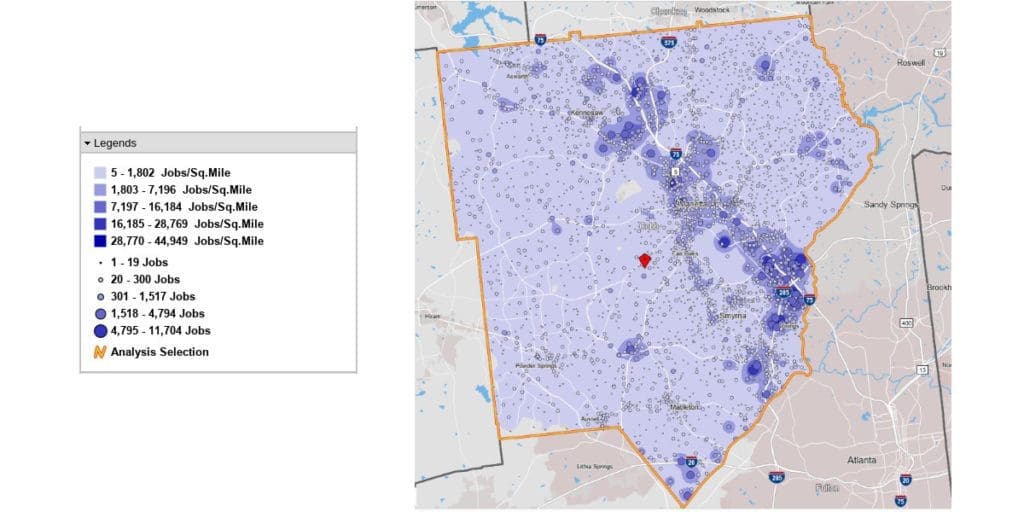
Here’s a paste-up of a screenshot of the map showing the concentration of jobs in Cobb County, and a map legend to show you how to interpret the color-coding (you can make it bigger by clicking on it):

As you can see, the Cumberland area along I-75 near the eastern border of the county is the largest single concentration of jobs.
But the job centers continue all the way up I-75 past Marietta and into the Kennesaw area. The job concentrations at the top end include Kennesaw State University, Town Center, and the intense cluster of commercial properties between Barrett Parkway on the south and McCollum Parkway on the north.
So at least in terms of jobs, I-75 is the economic engine of Cobb County.
The other significant job centers are the zone between South Cobb Drive and Atlanta Road around Plant Atkinson Road (near Georgia Power’s Plant McDonough-Atkinson), the industrial area at the southern tip of the county, the commercial area around the intersection of Austell Road and the East West Connector, and pockets of activity along Shallowford and Johnson Ferry roads in East Cobb.
One area we failed to mention in the earlier version of this article is the industrial park just west of South Cobb Drive and south of the East West Connector accessible via South Cobb Industrial Boulevard. That area has a heavy concentration of jobs.
How to get the info above, and a lot more, yourself
The videos below will teach you how to get census information from the OnTheMap tool yourself. It isn’t that hard!
