A dangerously high heat index is expected in Georgia until 8 p.m., along with potential severe thunderstorms today through Tuesday.
The National Weather Service issued a hazardous weather outlook along with a heat advisory for Cobb County and other parts of north and central Georgia for Wednesday, June 25.
Bonus for the more weather-curious among you … To read an article about interpreting a weather news report with some of the typical terminology defined, follow this link.
What is in the statement?
The statement gives the following details:
This Hazardous Weather Outlook is for north and central Georgia.
.DAY ONE…Today and Tonight…
Hazardous heat is expected in north and central Georgia today.
Heat index values will peak between 100 and 109 degrees between
noon and 8 PM. Precautions should be taken to prevent heat related
illnesses, especially for vulnerable populations like the
elderly, young children and pets.Isolated thunderstorms are expected after 1 PM today with more
widespread storms likely between 6 PM today and 4 AM Thursday.
Some of the storms could be severe with damaging winds in the 50
to 70 mph range being the primary concern. Some tree damage and
power outages may occur. Hail up to quarter size will be a
secondary threat with any severe storms..DAYS TWO THROUGH SEVEN…Thursday through Tuesday…
Scattered thunderstorms are expected Thursday afternoon and
evening. The strongest storms may produce damaging downburst
wind gusts in the 40 to 60 mph range.Additional scattered afternoon and evening thunderstorm activity
is expected each day through Tuesday.
What counties are affected?
The following counties are included in the hazardous weather outlook:
Baldwin, Banks, Barrow, Bartow, Bibb, Bleckley, Butts, Carroll, Catoosa, Chattahoochee, Chattooga, Cherokee, Clarke, Clayton, Cobb, Coweta, Crawford, Crisp, Dade, Dawson, DeKalb, Dodge, Dooly, Douglas, Emanuel, Fannin, Fayette, Floyd, Forsyth, Gilmer, Glascock, Gordon, Greene, Gwinnett, Hall, Hancock, Haralson, Harris, Heard, Henry, Houston, Jackson, Jasper, Jefferson, Johnson, Jones, Lamar, Laurens, Lumpkin, Macon, Madison, Marion, Meriwether, Monroe, Montgomery, Morgan, Murray, Muscogee, Newton, North Fulton, Oconee, Oglethorpe, Paulding, Peach, Pickens, Pike, Polk, Pulaski, Putnam, Rockdale, Schley, South Fulton, Spalding, Stewart, Sumter, Talbot, Taliaferro, Taylor, Telfair, Toombs, Towns, Treutlen, Troup, Twiggs, Union, Upson, Walker, Walton, Warren, Washington, Webster, Wheeler, White, Whitfield, Wilcox, Wilkes, Wilkinson
What is the heat index?
The NWS defines the heat index as follows on its website:
The heat index, also known as the apparent temperature, is what the temperature feels like to the human body when relative humidity is combined with the air temperature. This has important considerations for the human body’s comfort. When the body gets too hot, it begins to perspire or sweat to cool itself off.
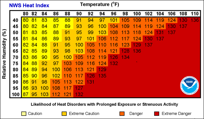
Chart from NOAA showing relationship between relative humidity and temperature in heat index
What is meant by “isolated” and “scattered”?
The NWS defines “isolated” as follows:
A National Weather Service convective precipitation descriptor for a 10 percent chance of measurable precipitation (0.01 inch). Isolated is used interchangeably with few.
“Scattered” has the following definition:
When used to describe precipitation (for example: “scattered showers”) – Area coverage of convective weather affecting 30 percent to 50 percent of a forecast zone(s).
Isolated thunderstorms and scattered thunderstorms are two terms used to describe different distributions of thunderstorm activity within a particular area. The main difference lies in the extent of coverage and how the thunderstorms are spatially distributed:
Isolated Thunderstorms:
- Isolated thunderstorms are relatively rare occurrences that happen sporadically and are generally confined to a limited area.
- These thunderstorms are often characterized by being few and far between, with significant gaps between individual storm cells.
- Typically, isolated thunderstorms cover less than 20% of the forecast area.
- Despite their isolated nature, these storms can still be intense and may produce heavy rain, lightning, gusty winds, and possibly hail.
Scattered Thunderstorms:
- Scattered thunderstorms are more widespread than isolated thunderstorms and cover a larger portion of the forecast area.
- In a scattered thunderstorm scenario, numerous individual thunderstorms develop, but they are not continuous or widespread enough to be classified as a “line” or “cluster” of storms.
- Scattered thunderstorms generally cover between 30% to 50% of the forecast area.
- Although scattered thunderstorms are more widespread, they still leave considerable gaps between storm cells, and not everyone within the forecast area will necessarily experience a thunderstorm.
In summary, isolated thunderstorms are fewer in number and more localized, covering a smaller area with significant gaps between storms, while scattered thunderstorms are more widespread, covering a larger area with numerous individual storms occurring somewhat randomly across the forecast area.
About the National Weather Service
The National Weather Service (NWS) is a part of the National Oceanic and Atmospheric Administration (NOAA).
The NWS describes its role as follows:
“The National Weather Service (NWS) provides weather, water, and climate forecasts and warnings for the United States, its territories, adjacent waters and ocean areas, for the protection of life and property and the enhancement of the national economy.
“These services include Forecasts and Observations, Warnings, Impact-based Decision Support Services, and Education in an effort to build a Weather-Ready Nation. The ultimate goal is to have a society that is prepared for and responds to weather, water and climate events.”