As predicted by the National Weather Service, Tropical Storm Erin was elevated to Hurricane Erin.
The center of the storm is likely to reach the northern Leeward Islands, the Virgin Islands, and Puerto Rico over the weekend, bringing with it heavy rains.
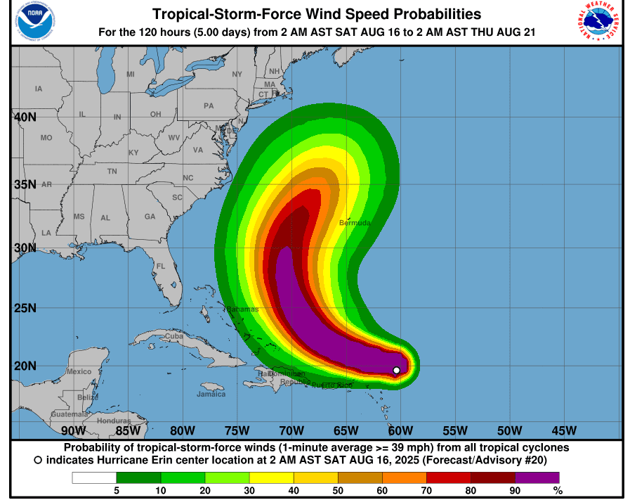
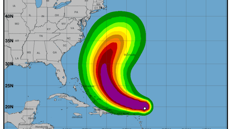
The National Hurricane Center posted the following:
Hurricane Erin is centered near 19.5N 59.5W at 16/0300 UTC or 215
nm ENE of Anguilla, and moving WNW at 15 kt. Estimated minimum
central pressure is 979 mb. Maximum sustained winds are 85 kt
with gusts to 105 kt. Numerous moderate to scattered strong
convection is occurring with 60 nm of the center. Peak seas are
around 30 ft near the center. On the forecast track, the center
of Erin is likely to move just north of the northern Leeward
Islands, the Virgin Islands, and Puerto Rico over the weekend with
a gradual decrease in forward speed. Rapid strengthening is
expected during the 24 to 36 hours, and Erin is forecast to become
a major hurricane during the weekend. Swells generated by Erin
will begin affecting portions of the northern Leeward Islands, the
Virgin Islands and Puerto Rico by this weekend, and will likely
spread to the western Atlantic next week. These swells are likely
to cause life-threatening surf and rip current conditions. The
outer rainbands of Erin are expected to produce areas of heavy
rainfall tonight into Sunday across the northern Leeward Islands,
the Virgin Islands, and Puerto Rico. This rainfall may lead to
isolated and locally considerable flash and urban flooding, along
with landslides or mudslides.
Above-normal Atlantic hurricane season expected
The National Weather Service forecasts that we are on track for an above-normal hurricane season this year.
The National Hurricane Center posted the following:
Forecasters from NOAA’s National Weather Service updated the number of expected named storms to 13-18 (with winds of 39 mph or greater), of which 5-9 could become hurricanes (winds of 74 mph or greater), including 2-5 major hurricanes (winds of 111 mph or greater).
The adjusted ranges are for the entire season from June 1 though November 30, and are inclusive of the four named tropical storms that have already formed. In the Atlantic basin, a typical hurricane season will yield 14 named storms, of which seven become hurricanes and three become major hurricanes.
The likelihood of above-normal activity is 50%, a 35% chance of a near-normal season, and a 15% chance of a below-normal season. This updated prediction is similar to the initial outlook issued in May.