
Cobb County and other parts of north and central Georgia are under a heat advisory until midnight Sunday, July 2.
Portions of the region are expected to have 100-110 degree heat index through next Thursday.
There is a chance of afternoon thunderstorms (2 out of 5 for north Georgia, 1 out of 5 for other parts of the region).
What is the heat index?
The NWS defines the heat index as follows on its website:
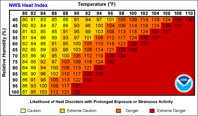
The heat index, also known as the apparent temperature, is what the temperature feels like to the human body when relative humidity is combined with the air temperature. This has important considerations for the human body’s comfort. When the body gets too hot, it begins to perspire or sweat to cool itself off.
Chart from NOAA showing relationship between relative humidity and temperature in heat index
What is in the statement?
The statement from the National Weather Service gives the following details:
This Hazardous Weather Outlook is for portions of North and Central Georgia.
.DAY ONE…Today and Tonight…
The probability of widespread hazardous weather is low.
A Heat Advisory is in effect for much of north and central Georgia
today. Heat index values are expected to reach or exceed 105. If
spending time outdoors, be sure to stay hydrated, wear lightweight
clothing, and take plenty of time to rest.
Thunderstorms will be possible this afternoon and evening. A few
of these could be severe. A Slight Risk (2 out of 5) is in effect
for portions of north Georgia, with the rest of north and central
Georgia in a Marginal Risk (1 out of 5). The primary threat with
any storms that do form will be damaging wind gusts, frequent
lightning, and isolated flash flooding from heavy rainfall.
.DAYS TWO THROUGH SEVEN…Sunday through Friday…
Hot and humid conditions will lead to elevated heat index values
between 100-110 degrees across portions of the forecast area from
Sunday through Thursday. A Heat Advisory is in effect for the
majority of north and central Georgia from 8AM Saturday through
midnight Sunday.
Additionally, scattered to numerous afternoon and evening
thunderstorms are possible each day Sunday through Thursday. Some
storms may become strong to severe with damaging wind gusts,
large hail, frequent lightning, and locally heavy rainfall
leading to isolated flash flooding being the primary hazards.
.SPOTTER INFORMATION STATEMENT…
Spotter activation is not requested but spotters are encouraged
to submit reports of severe weather through the web by going to
weather.gov/atlanta. Please relay any information about observed
severe weather to the NWS while following all local, state, and
CDC guidelines.
What counties are affected?
The following counties are included in the hazardous weather outlook:
Baldwin, Banks, Barrow, Bartow, Bibb, Bleckley, Butts, Carroll, Catoosa, Chattahoochee, Chattooga, Cherokee, Clarke, Clayton, Cobb, Coweta, Crawford, Crisp, Dade, Dawson, DeKalb, Dodge, Dooly, Douglas, Emanuel, Fannin, Fayette, Floyd, Forsyth, Gilmer, Glascock, Gordon, Greene, Gwinnett, Hall, Hancock, Haralson, Harris, Heard, Henry, Houston, Jackson, Jasper, Jefferson, Johnson, Jones, Lamar, Laurens, Lumpkin, Macon, Madison, Marion, Meriwether, Monroe, Montgomery, Morgan, Murray, Muscogee, Newton, North Fulton, Oconee, Oglethorpe, Paulding, Peach, Pickens, Pike, Polk, Pulaski, Putnam, Rockdale, Schley, South Fulton, Spalding, Stewart, Sumter, Talbot, Taliaferro, Taylor, Telfair, Toombs, Towns, Treutlen, Troup, Twiggs, Union, Upson, Walker, Walton, Warren, Washington, Webster, Wheeler, White, Whitfield, Wilcox, Wilkes, Wilkinson
About the National Weather Service
The National Weather Service (NWS) is a part of the National Oceanic and Atmospheric Administration (NOAA).
The NWS describes its role as follows:
“The National Weather Service (NWS) provides weather, water, and climate forecasts and warnings for the United States, its territories, adjacent waters and ocean areas, for the protection of life and property and the enhancement of the national economy.
“These services include Forecasts and Observations, Warnings, Impact-based Decision Support Services, and Education in an effort to build a Weather-Ready Nation. The ultimate goal is to have a society that is prepared for and responds to weather, water and climate events.”
>>> Read all the Cobb County Courier climate and weather coverage by following this link.