
The National Weather Service issued a hazardous weather outlook for Cobb County and other counties in the region for Sunday Aug 13, 2023.
Until 9 a.m. patchy fog is forecast, a heat advisory is in effect for the afternoon, and afternoon thunderstorms are expected.
For more information on what a high heat index means, and what it means to expected “scattered thunderstorms,” read to the bottom of this article for explanations.
What is in the statement?
The hazardous weather outlook gives the following details:
This Hazardous Weather Outlook is for portions of North and
Central Georgia.
.DAY ONE…Today and Tonight…
Patchy fog in portions of far north and northwest Georgia will
restrict visibilities to a quarter of a mile or less until 9 AM
EDT. If driving this morning, slow down, use low-beam headlights
and leave extra distance between you and the vehicle in front of
you.
An Excessive Heat Warning is in effect for portions of central and
east Georgia, roughly along and south of a line from Washington to
Fincherville to Hamilton, from 10 AM to 8 PM EDT. Heat Index
values exceeding 110 degrees will be likely in this area.
A Heat Advisory is also in effect to the north of the Excessive
Heat Warning, roughly along and south of a line from Homer to
Alpharetta to Carrollton, from 10 AM to 8 PM EDT. Heat Index
values between 105-109 degrees will be likely in this area.
Scattered thunderstorms are expected this afternoon and evening,
with the highest chances in west Georgia. Several storms could
become strong, capable of producing gusty winds, frequent
lightning, and locally heavy rain.
.DAYS TWO THROUGH SEVEN…Monday through Saturday…
An Excessive Heat Watch has been issued for central and portions
of north Georgia for Monday, mainly along and south of a line
from Homer to Alpharetta to Franklin. Heat Index values exceeding
110 degrees are possible.
Heat Index values will remain high for portions of central and
south Georgia through early next week. Additional heat-related
advisories and/or warnings may be needed. Take extra precautions
and drink plenty of fluids if you plan to spend time outside today
or early next week.
Periods of thunderstorm activity will continue through next Saturday.
The highest storm chances will occur during the afternoon and evening
hours each day.
.SPOTTER INFORMATION STATEMENT…
Spotter activation will not be needed through tonight.
What counties are affected?
The following counties are included in the hazardous weather outlook:
Baldwin, Banks, Barrow, Bartow, Bibb, Bleckley, Butts, Carroll, Catoosa, Chattahoochee, Chattooga, Cherokee, Clarke, Clayton, Cobb, Coweta, Crawford, Crisp, Dade, Dawson, DeKalb, Dodge, Dooly, Douglas, Emanuel, Fannin, Fayette, Floyd, Forsyth, Gilmer, Glascock, Gordon, Greene, Gwinnett, Hall, Hancock, Haralson, Harris, Heard, Henry, Houston, Jackson, Jasper, Jefferson, Johnson, Jones, Lamar, Laurens, Lumpkin, Macon, Madison, Marion, Meriwether, Monroe, Montgomery, Morgan, Murray, Muscogee, Newton, North Fulton, Oconee, Oglethorpe, Paulding, Peach, Pickens, Pike, Polk, Pulaski, Putnam, Rockdale, Schley, South Fulton, Spalding, Stewart, Sumter, Talbot, Taliaferro, Taylor, Telfair, Toombs, Towns, Treutlen, Troup, Twiggs, Union, Upson, Walker, Walton, Warren, Washington, Webster, Wheeler, White, Whitfield, Wilcox, Wilkes, Wilkinson
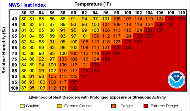
What is the heat index?
The NWS defines the heat index as follows on its website:
The heat index, also known as the apparent temperature, is what the temperature feels like to the human body when relative humidity is combined with the air temperature. This has important considerations for the human body’s comfort. When the body gets too hot, it begins to perspire or sweat to cool itself off.
Chart from NOAA showing relationship between relative humidity and temperature in heat index
What is the difference between “isolated” and “scattered”?
The NWS defines “isolated” as follows:
A National Weather Service convective precipitation descriptor for a 10 percent chance of measurable precipitation (0.01 inch). Isolated is used interchangeably with few.
“Scattered” has the following definition:
When used to describe precipitation (for example: “scattered showers”) – Area coverage of convective weather affecting 30 percent to 50 percent of a forecast zone (s).
In other words isolated means a few showers, scattered means the showers are likely to cover 30 to 50 percent of the affected region.
More climate coverage from the Cobb County Courier
Satellites detect no real climate benefit from 10 years of forest carbon offsets in California
4 signs of progress at the UN climate change summit
About the National Weather Service
The National Weather Service (NWS) is a part of the National Oceanic and Atmospheric Administration (NOAA).
The NWS describes its role as follows:
“The National Weather Service (NWS) provides weather, water, and climate forecasts and warnings for the United States, its territories, adjacent waters and ocean areas, for the protection of life and property and the enhancement of the national economy.
“These services include Forecasts and Observations, Warnings, Impact-based Decision Support Services, and Education in an effort to build a Weather-Ready Nation. The ultimate goal is to have a society that is prepared for and responds to weather, water and climate events.”
>>> Read all the Cobb County Courier climate and weather coverage by following this link.