NOTE TO READERS: One thing I’ve discovered in testing the map is that if you access it via a mobile device and it takes you to the web address ending in “/amp” (for Accelerated Mobile Pages) you get a tiny version of the map which is tedious to navigate. I’m working on a solution to that, but access is better on a PC.
FURTHER NOTE: I’ve disabled the AMP version of the page so that even on mobile devices you are sent to the main web page.
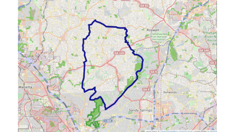
Using the non-interactive map on the East Cobb Cityhood website as a guide to determine the borders, I’ve constructed an interactive map of the proposed new City of East Cobb using Open Street Maps. You can jump right to the map at the bottom of the article if you wish.
I’ve categorized this post as From the Editor since I want to write in first person about the map, and ask readers what improvements they’d like to see in future maps. And if anything doesn’t work, please contact me, either by commenting under the article, or at the contact link on our website. I consider these maps (and our charts and graphs) an important part of our mission for the future.
The map on the East Cobb Cityhood website had mislabeled one border as Joe Jerkins Blvd (which is actually in Austell, across the county). In context I assumed the actual road was Paper Mill Road.
The sloppy border termination I created at the Davis Road/Shallowford Road intersection will be corrected later, but since the map was tedious to build I didn’t want to risk deleting the whole border while trying to correct the error.
Like all interactive maps you can zoom in and out to get a better idea of the details and high level context.
Here are the borders described in a clockwise way. If this gets confusing just refer to the map below.
Starting at the intersection of Shallowford Road and Davis Road, move eastward along Shallowford Road to the Fulton County line.
Move southward and along the river until you reach the mouth of Sope Creek.
Then head up Sope Creek to Paper Mill Road.
Turn westward on Paper Mill Road.
Go northward on Shadowlawn Road to Lower Roswell Road and turn left (southwestward).
On Old Canton Road turn northward (right) a take Old Canton to Sewell Mill Road where you will head eastward to Murdock Road, then north along Murdock Road.
You’ll then turn east (right) on Post Oak Tritt Road and take a left on Hembree Road.
You’ll then follow the creek located to the west of Pope High School northward to Davis Road, head eastward on Davis Road, back to the beginning point at the intersection of Davis Road and Shallowford Road.
And here’s the map. The little square box on the left hand side will give you a fullscreen view:
I’ve always been told that East Cobb was everything East of 75 or at a minimum, East of Powers Ferry. This map has the children of East Cobb Middle School not living within the boundaries of the city of East Cobb. This revised map cuts out a lot of people who for decades have said they live in East Cobb. The original maps included most of the area for Wheeler and East Cobb Middle why this one does not. Why the change?
Great point, Stephanie. The elephant in the room… The city might as well be call White East Cobb. (I am white.)
Self hatred based upon physical characteristics is an unhealthy habit, John
*Called*
A group of somebodies is on a power trip.
This “East Cobb City” concept smacks of Real Estate Agent meglomania, and lacks good common sense.
even the name “East Cobb City” is just a little ridiculous, like trying to pat yourself on the back.
Self-government is always a better idea,,,,but I think the good people of East Cobb better work with the good people of Regular Cobb on more practical city limits…
And please……please….come up with a better name than “East Cobb city”. Please!
Why another layer of government? Have lived here for the past 23 years, I am very satisfied with the service Cobb county provides. No to city of east cobb, no to new taxes, no to more government bodies!
I read all the committee members’ resumes and was surprised to learn there isn’t a member with a Civil/Architecture background. So I would volunteer to be considered as a member. I have degrees: Ph.D. from Duke University in Civil/Structural Engineering, MS from VPI, and BS from CKU primary interests in Civil/Architectural Engineering. I was Endowed and tenured Full Professor with LSU for 37 years and retired in 2013, and then moved to East Cobb in 2014. I have been a licensed Profesional Engineer in the United States for almost 50 years.
Bert Lance, former Director of OMB under Jimmy Carter, reportedly said it first and said it best.
“If it ain’t broke don’t fix it”
I have lived in East Cobb my entire life. Born and raised. This is cutting out a significant portion of East Cobb residents and the community. It’s taking a small subset of an affluent East Cobb area and creating a new East Cobb. More importantly East Cobb City is not justified. What is the reason? I’m disappointed. It should be more inclusive and not
more exclusive.
Disgusting…. How fair is this to the residents of River Heights and River View near the end of Columns Drive??? Why are THEY not included in this? Is Cobb Fire and Police expected to cut all the way across The City Of East Cobb to come help these residents if in need because that’s nearly the only practical way into those areas…Or is this map proposal really this half-assed?
The push to make east cobb a city is a typical example of corruption in government,
large developers greed and financial side deals. Those people who thinks it is a good idea,are either misinformed ,uninformed, stand to gain favors or have below room temp
IQ !!!
Big mistake! I do not support City of East Cobb. We have great service from Cobb County Government. Great police, fire and parks. I will not vote for this bill.
I have lived in Cobb County all my life. If this bill passes I guess it’s time to move.